|
Author: Emily Schottenfels When we think of natural disasters in Boston, what comes to mind are hurricanes, floods, sea level rise, or possibly fires, Snowmageddon, and even the occasional Great Molasses Flood. Earthquakes are not our greatest concern, yet there are records of earthquakes that shook New England, causing serious damage to infrastructure and lasting impacts to society. According to the United States Geological Survey, New England has a low to moderate earthquake hazard. Most of the earthquakes in New England have been <5.0 magnitude (Mw), but some significant earthquakes >Mw 5.0 occurred in the last few hundred years. What kind of damage can an earthquake cause to Boston? Let’s take a look at significant historical earthquakes in New England to learn more. 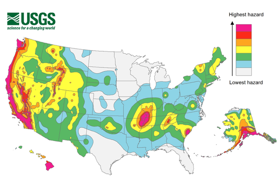 US Geological Survey (USGS) seismic hazard map Wait, how do we know the magnitude and locations of earthquakes before modern technology? Unlike earthquakes today, the intensity of historical earthquakes cannot be measured directly using instruments. Instead, we rely on personal accounts of historic earthquakes including location, intensity of shaking, damage to infrastructure, and feeling aftershocks. These personal recollections are classified according to a scale of earthquake intensity, called the Modified Mercalli Intensity Scale. This scale, denoted by Roman Numerals, ranges from imperceptible ground shaking to catastrophic destruction of well-built structures. The Modified Mercalli Intensity Scale is then mapped, and the earthquake magnitude is determined based on this spatial distribution. While personal accounts may cause some uncertainty surrounding historical earthquake magnitudes, this approach combined with geologic and seismic knowledge of the area, provides strong estimates for past earthquakes. 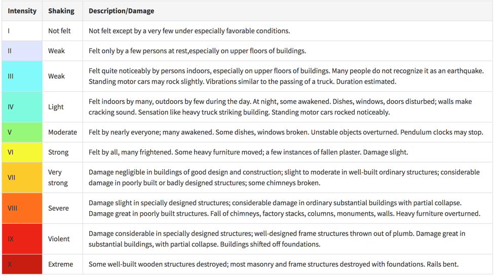 Modified Mercalli intensity Scale (USGS) Historical earthquakes in New England Sorry, Pilgrims: Not long after European settlers arrived on the Mayflower, a severe earthquake, now considered to be between a Mw 6.5 and Mw 7, struck central New Hampshire on June 11, 1638 (dates may differ due to changes from the Julian calendar). Although there are not many personal records of the event, the earthquake was felt along the St. Lawrence River in Quebec by Native Americans at Trois Rivieres and all the way to Boston, where people lost their footing and fell to the ground. A noticeable but an undetermined number of aftershocks continued to shake New England for months afterwards. This event impacted settlers to such a degree that New Englanders often dated events based on the years "so long since the earthquake." Governor John Winthrop of Massachusetts Bay Colony recorded in his journal,
Still no rest for the early settlers: About 25 years after the 1638 New Hampshire earthquake, the largest known earthquake to rock New England occurred on February 5th, 1663 with a magnitude 7.5 in Charlevoix, Quebec. This large earthquake caused extensive damage across the northeast. In Boston chimneys fell, walls collapsed, and people ran into the streets to seek refuge. In Quebec, the earthquake uprooted trees, triggered landslides along the St. Lawrence river, and many aftershocks shook the region for months. Rev. Danforth of Roxbury, MA noted,
Chim chiminey, chim chiminey, chim chim cher-ee: The largest earthquake to strike closest to Boston was the 1755 Cape Ann Mw 6.2 earthquake. The Cape Ann earthquake damaged hundreds of buildings along the east coast from Halifax, Nova Scotia to Winyah, South Carolina. In addition to historical accounts of shaking, the intensity of this earthquake was determined by records of damage to infrastructure, specifically to chimneys. Reports of chimneys across New England with no damage, minor damage, or extensive damage were used to determine the location and intensity of the earthquake. Of approximately 5000 documented chimneys in Boston at that time, roughly two thirds were moderately to severely damaged by the quake and roughly 100 chimneys in Boston were leveled. Reports from other towns in the northeast, such as York, Maine, Braintree, MA, Northampton, MA, New Haven, and NYC, all indicated damage to chimneys. Beyond chimney damage, brick walls and stone fences fell down, and there were reports of cracks in streets in Eastern Massachusetts. The Boston Weekly News-Letter reported on Nov. 20th, 1755:
 Photo depicting the scenes of the earthquake. Source: New England Historical Society Double the fun: On December 20th and 24th, 1940, two earthquakes of similar magnitude (Mw5.5) rocked New Hampshire at the northern base of the Ossipee Mountains. Though the first shock was stronger, the second shock may have caused more damage since the structures were already weakened by the first shock. Nearby towns reported chimney damage, muddy well water, cracked walls, and broken furniture. Reports of minor damage stretched across Maine, New York, Vermont and Massachusetts. The shocks were felt from Quebec to Connecticut. According to the Springfield Republican Newspaper, in Springfield, MA,
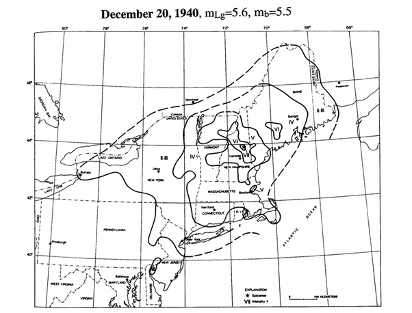 Intensity of shaking map of the 1940 earthquake in New Hampshire (Ebel, 1996) More Information on Earthquakes in New England Earthquakes in New England are caused by the fracturing of preexisting “weak” regions, which are due ancient tectonic activity. Ancient faults identified and mapped by geologists could reactivate, but it is not well understood if the earthquakes in New England even occur on these known faults. Additionally, much of the Boston area is built on unconsolidated sediments. This increases the likelihood of liquefaction, which amplifies ground shaking and causes more damage to infrastructure. It wasn’t until the 1970s that researchers in New England installed a seismic network to monitor and detect earthquake on a regular basis. Since then, thousands of earthquakes have been detected, but not enough information has been gathered to understand which faults are active and host earthquakes. Though large earthquakes in Boston are few and far between, they can still cause extensive damage. Check out this website to learn more about earthquakes in New England, and this website to get the latest info on earthquakes from the New England Seismic Network. Web Sources: Weston Observatory, New England Seismic Network Earthquakes in Boston, Boston Globe article USGS 1638 earthquake 1663 Earthquake, from the New England Historical Society The Northeast States Emergency Consortium (NESEC) Literature Sources: Ebel, J. E., Somerville, P. G., & McIver, J. D. (1986). A study of the source parameters of some large earthquakes of northeastern North America. Journal of Geophysical Research: Solid Earth, 91(B8), 8231-8247. Ebel, J. E. (1996). The seventeenth century seismicity of northeastern North America. Seismological Research Letters, 67(3), 51-68. Ebel, J. E. (2006). The Cape Ann, Massachusetts earthquake of 1755: A 250th anniversary perspective. Seismological Research Letters, 77(1), 74-86.
0 Comments
Leave a Reply. |
